- This event has passed.
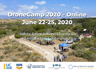
UCANR 2020 Drone Camp – ONLINE
Registration for DroneCamp Online is now Live!
We’ve managed to retain most of the workshops for the online version of DroneCamp  , with the exception of the flight practice sessions
  . Check out the workshop summary and schedule at a glance below.
Super low registration for 4 days of content! General admission – $50; Academic rate – $30
Now in its 4th year, DroneCamp is a collaborative intensive short course providing comprehensive training on using drones for mapping and data collection. Instructors from the University of California and California State University systems will teach you how to select hardware, plan flights for data collection, prepare equipment, fly safely and legally, process and manage data, conduct analyses, and visualize results for a range of applications including:
Agriculture • Land Management • Facilities Inspections • Environmental Monitoring • Forestry • Research
Who Should Attend DroneCamp?

ONLINE
Short answer: Anyone interested in using drones for mapping or data collection!
DroneCamp is designed for a wide range of skill levels and interests, from complete beginners with little to no experience in drone technology, to intermediate users who want to learn more advanced data processing and analysis.
Note the focus of DroneCamp is using drones for mapping, research and data collection. We do not cover building drones, robotics, or videography. Regulations and safety will be discussed but this is not a full-fledged Part 107 prep class.
Experience with drones or GIS is not required.
Workshops
- Flight Skills: Night Flying (unfortunately we can’t do flight practice online, but we’ll recommend resources for learning how to fly)
- Safety and Regulations: Safety and Regulations Overview; How to be a Good Visual Observer; Operating in Controlled Airspace
- Hardware: Sensors, Platforms and Field Accessories
- Data Collection: Mission Planning; High Precision Mapping
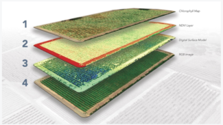
- Data Analysis: Stitching Drone Images with Pix4D, Agisoft Metashape, ArcGIS Pro, and OpenDroneMap; Analyzing Processed Drone Data in QGIS and ArcGIS Pro; Advanced Analytics for Vegetation Analysis, Vegetation Analysis and Classification in ArcGIS Pro; Sharing Data and Outputs; Analysis of the Intertidal Zone
Online Format
In response to the COVID19 pandemic, all DroneCamp sessions will be online, primarily using Zoom. Workshops will include lecture style, short talks, and hands-on software training with live instructors.
Note: Hands-on workshops using software will require participants to install software on their own computers. Setup instructions for each workshop will be provided, including minimum hardware requirements, where to download the software, and getting a trial license if needed. A limited amount of technical assistance will be available and we’ll have a drop-in help session the day before DroneCamp starts, but ultimately installing software is the sole responsibility of each participant.
Schedule at a Glance
Subject to change! Final schedule will be posted in mid-May – please check back then for updates. All times are Pacific Daylight time. All sessions will be recorded and shared with registered participants as soon as we get them from Zoom (within a couple of hours).
Friday June 19, 2020
Getting ready
9:00 – 11:00 am & 14:00 – 16:00 pm. Drop-in Tech Support Sessions.
Make sure your Zoom is working, and you have all the software and data needed for the hands-on workshops.
Monday June 22, 2020
What you need to know before you go to the field
9:00 am. Welcome and Overview
9:10 – 9:50 am. Drone Mapping Workflow Overview and Applications
10:00 – 10:50 am. Equipment Short Talks; Breakout Q&A
11:00 – 11:50 am. Drone Safety and Regulations Overview
14:00 – 14:50 pm. Mission Planning Principles, Best Practices and Tools
15:00 – 15:50 pm. Planning for the Field; Preparing Your Equipment
Tuesday June 23, 2020
What you need to know in the field; Image processing #1
9:00 – 9:50 am. Introduction to Photogrammetry and Data Processing
10:00 – 11:50 am. Data Processing Workshops (select one)
- Data processing with Pix4Dmapper
- Data processing with ArcGIS Pro
14:00 – 14:50 pm. How to be a Good Visual Observer
15:00 – 15:50 pm. High Precision Mapping
Wednesday June 24, 2020
Image Processing #2; Data Analyses Pt 1
9:00 – 9:50 am. Data Management and Sharing Results
10:00 – 11:50am. Data Processing Workshops (select one)
- Data processing with Agisoft Metashape
- Processing data with Open Drone Map
14:00 – 15:50 pm. Analyzing Drone Outputs with GIS Workshops (select one)
- Mapping and Analyzing Processed Data in ArcGIS Pro
- Multispectral Data Visualization and Extraction with QGIS
Thursday, June 25, 2020
Advanced Flight Operations; Data Analyses Pt 2
9:00 – 9:50 am. Participant Speed Talks 
10:00 – 11:50 am. Concurrent Workshops (select one)
- Vegetation Classification with ArcGIS Pro
- Operating in Controlled Airspace; Night Flying
12:00 – 12:50. Monterey Bay DART Turns Five! Celebrating the past, Planning for the Future
14:00 – 15:50 pm. Deep Dives by Field (select one)
- Agriculture
- Digital Agriculture
- Sensing Crop Water Stress with Thermal Imagery
- Marine & Aquatic Systems
- Data Analysis in the Intertidal Zone
15:50 – 16:00 pm. Thanks and Closing
Registration & Fees
One low price for all content:
General admission: $50
Academic rate*: $30
* to get the academic rate you much register with a .edu email address
Scholarships and Discounts
UCANR. We are pleased to offer scholarships for all UCANR employees to attend DroneCamp Online. Select the Scholarship option when registering. A short application to verify eligility is required.
CSU Monterey Bay students and faculty. A limited number of complementary registrations are available for students and staff of CSU Monterey Bay. Please contact uassafety@csumb.edu for details.
June 22, 2020 @ 8:00 am – June 25, 2020 @ 5:00 pm
Latest News
 Take Flight at FIRA-USA 2024: Join Monterey Bay DART’s Drone Pavilion!April 10, 2024 - 5:14 pm
Gear up for takeoff, drone innovators! Monterey Bay DART is is pleased to announce its partnership with HawkTower and to once again host a premium drone pavilion during the FIRA-USA event October […]
 Soar into the Future with a DroneCamp Scholarship!April 10, 2024 - 3:37 pm
Are you passionate about drones and their potential to change the world? This blog post is for you! The Monterey Bay DART DroneCamp Scholarship Program is offering financial aid to […]