
La Selva Beach, CA, May 24, 2023 (GLOBE NEWSWIRE) — Leading heavy-lift drone developer, Parallel Flight Technologies, announces a significant deal involving the sale of 50 autonomous aircraft to India-based drone and robotics solutions provider, UAV Systems Private Limited (UAVS). Alongside the deal, Parallel Flight will also ensure seamless functioning of these platforms through its continuous maintenance, repair, and overhaul services. Deliveries under this agreement are set to commence in 2024.
This monumental agreement marks a pivotal step in Parallel Flight’s international expansion, strengthening its position as a top-tier UAV solution provider in India. The alliance will bring forth customer-centric solutions that blend cutting-edge technology, safety, high efficiency, and affordability across various industries.
UAV Systems Private Limited, supported by various prominent Indian conglomerates, is an expert in UAV solutions, demonstrating a solid track record in penetrating emerging markets with turnkey solutions. The Indian market exhibits broad acceptance of drone technology across sectors such as energy, agriculture, renewables, mining, conservation/reforestation, defense, law enforcement, and several other industrial logistics applications.
“We chose to collaborate with Parallel Flight owing to their unique technology, inventive approach, customer comprehension, and the commendable backgrounds of their team,” states Arab Khan, CEO of UAV Systems. He adds, “The proficiency of their scientists and engineers in creating outstanding heavy-lift drone technology fills a technology gap in India. We are excited about this partnership and anticipate the demand for Parallel’s units to increase to over 500 in the upcoming years.”
Read more here: https://www.santacruzworks.org/news/parallel-flight-technologies-inks-multi-million-dollar-aircraft-deal

Island Conservation, a leading global nonprofit organization that restores and protects island-ocean ecosystems by removing destructive invasive species, has announced a strategic partnership with Parallel Flight Technologies, a California-based company specializing in heavy-lift drone and hybrid propulsion technology.
This partnership is expected to advance Island Conservation’s critical island restoration initiatives to new heights.
Islands are biodiversity hotspots that are home to an incredible range of birds and terrestrial animals, as well as abundant marine life in the surrounding ocean. However, they are also vulnerable to destructive invasive species, such as rodents that destroy natural habitat. Roughly 75 percent of reptile, bird, amphibian, and mammal extinctions combined have occurred on islands with invasive species as a primary cause. Removing this threat is crucial to ensuring ecological balance and diversity.
“Frequently, conducting invasive species eradications in order to protect these ecosystems involves huge logistical and resource challenges,” says David Will, Head of Innovation at Island Conservation. “Because of this, we have pioneered the use of drones in invasive rodent eradications to overcome the cost and skill barriers to conventional ground and helicopter-based approaches. However, we’ve reached the limits of what current all-electric drone technology can achieve.”
The solution lies in hybrid unmanned aircraft systems (UAS) with large payload capacities and long-range capabilities that can meet the demands of conservation interventions in remote locations. Parallel Flight Technologies offers a groundbreaking aircraft with hybrid propulsion technology that gives it a combination of lift, endurance and portability which are ideal to advance Island Conservation’s field efforts.
“We see this technology as a game-changer, and we believe that it will allow us to achieve our goal to restore globally important islands more efficiently, effectively and sustainably,” says Will.
The aircraft can carry and spread a total payload capacity of approximately 100 pounds (45 kilograms) for over 1.6 hours of flight time and can autonomously fly pre-programmed flight paths while accurately delivering bait at prescribed application rates. The hybrid propulsion technology is highly efficient and relies on locally sourced fuels, eliminating the need for costly, wasteful batteries. It also dramatically reduces the carbon footprint and power requirements of continuous aerial operations in remote locations.
“Our work with Parallel Flight Technologies is timely, inspiring and necessary,” says Penny Becker, Vice President of Conservation at Island Conservation. “The continued development and adaptation of Parallel Flight Technologies’ autonomous heavy-lift drone technology will enable a significant increase in safety parameters and exponentially increase efficiency over traditional methods. With this drone technology, we will be able to restore islands on a much larger scale and in remote places that were once prohibitive, protecting more island wildlife, oceans and communities.”
Islands are biodiversity hotspots. Restoring islands is repeatedly proven to be one of the best interventions for protecting biodiversity and creating resilient, thriving ecosystems. Photo: Island Conservation.
Read More: https://www.santacruzworks.org/news/island-conservation-and-parallel-flight-technologies-partner-to-revolutionize-the-restoration-of-islands-worldwide
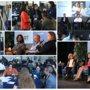
The CITRIS Institute for Drone education and Research (CIDER) at the University of California at Santa Cruz, in partnership with Monterey Bay Drone Automation and Robotics Technologies (DART), Airspace Integration, and ATA LLC, is developing the Central Coast Flight Information Exchange (CC-FIX). CC-FIX is a risk-based, federated approach to creating an “aeronautical information service-like” capability for the integration of Uncrewed Aerial Systems (UAS) and Advanced Air Mobility (AAM) into the airspace with the continued commitment to keep the airspace open, secure, and safe. This coalition believes that a functional CC-FIX will accelerate UAS and AAM related R&D, providing significant economic development opportunities for Central California and communities across the state.
The Central Coast Flight Information Exchange (CC-FIX) integrates federal laws and regulations, state and local advisories, public safety advisories, environmental sensors, weather sensors, data feeds, operations platforms, surveillance technologies and ground hazards (i.e. towers, buildings, population centers, etc.) through a public platform. Rather than needing to go to multiple places to access this important data, every person using a flight planning application that has a relationship with one of the participating approved UAS Service Suppliers will see CC-FIX data in their flight planning or control software or through the CC-FIX public website. That brings all this critical information together making it available in one place. If you ask any operator, especially in the public safety community, this is a huge leap forward in the communications and coordination needed to ensure that we take full advantage of the opportunities created by AAM and to integrate with the national airspace system safely.
The speed with which the UAS and AAM industry is developing continues to surprise and is putting pressure on needed changes to the fundamentals of aviation management. The FAA recognizes this in both its UAS Traffic Management (UTM) Concept of Operations (ConOps) and through the UAS Data Exchange Low Altitude Approval Notification Capability (LAANC) program; both of which acknowledge that existing air traffic management models alone do not adequately address the challenge of integrating UAS and other AAM transportation modalities into the national airspace. We’ve discovered through our current work that the best way to realize the infrastructure needed is to do it in a collaborative manner, working public-private partnerships across the industry and encouraging the creation of new relationships. This way we can actually get to UAS and AAM operations at scale much more quickly in a more cost-effective and resilient manner.
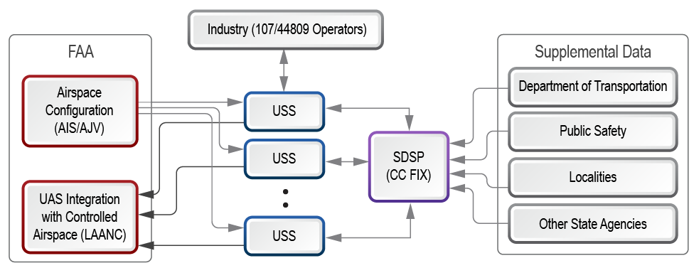
CC-FIX allows for multiple ways to connect and share information, including web-based and programmatic alternatives. The system is intentionally designed to leverage current standards, open-source technologies, and existing background intellectual property to keep costs low. As a robust, cloud-based service, the technology underlying CC-FIX can quickly meet growing statewide and national demand. The intuitive user interface requires only a brief orientation during new user onboarding. CC-FIX is consistent with the FAA’s vision of a “community-based” system of industry, federal, and state and local governments cooperating to manage the anticipated heavy volumes of UAS traffic at low altitudes. CC-FIX sits at the center of this ecosystem enabling USS and commercial UTM providers to consume and share authoritative state data as a public service.
URL for the Central Coast Flight Information Exchange (CC-FIX): http://cc-fix.com/
Coalition Partner Contacts:
University of California – Santa Cruz
Michael Matkin
Assistant Director
CITRIS and the Banatao Institute
Baskin School of Engineering
(831) 459-4464
mmatkin@ucsc.edu
Monterey Bay DART
Josh Metz, Executive Director
(831) 264-8299
josh@montereybaydart.org
Airspace Integration
Chris Bley, CEO
(831) 428-6655
bley@airspaceint.com
ATA, LLC
Scott Drew, UAS Project Manager
(804) 814-8148
sdrew@ata-llc.com
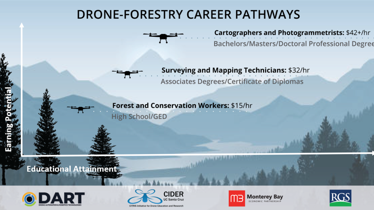
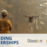
The fields of drones (Uncrewed Aerial Systems, UAS), automated systems, and robotics technologies (DART) have rapidly advanced over the past decade yielding new tools for environmental management and a broad array of other applications. These technological innovations are the result of both public and private research & development investment, and represent emerging markets for future workforce engagement. Over this same time period we have experienced increasingly frequent occurrences of climate driven catastrophes such as wildfire, drought and floods. As a result, there is real urgency to conceive of novel solutions to these environmental challenges. The hope is that drones and related technologies of remote sensing and spatial analysis can be part of those solutions, while providing value through generating future workforce opportunities.
Data collected by drones can be applied to a variety of environmental management fields including agriculture, environmental conservation, timber management, watershed management, climate change monitoring, disturbance mitigation, wildland management, fire management, and urban-wildland interface management among many others. Imagery data captured by drones for the purposes of land management and ecosystem monitoring can be used to evaluate ecosystem health under stress (Daly 2019), track and monitor wildlife (Prosekov et al 2020), pest outbreaks and disease spread (Filho et al 2020), ecosystem regeneration after disturbance, shifts in ecosystem after disturbance (Jiménez et al 2019), and monitor fires (Aydin et al 2019, Afghah et al 2019) among many other applications.
As drones become indispensable tools for land management, with the capabilities of drones to collect high frequency, high resolution data on a variety of spatial and temporal scales. We recognize that a critical priority for California is to have a workforce ready and able to support the innovation, manufacturing, and application of drones across a wide variety of industries.
With an eye towards informing workforce developers, educators and policy-makers focused on meeting the urgent need for a future focused forest management workforce, this paper provides:
Recognizing the inherent limitations of projecting emerging technology skill demands based on backward looking datasets, this paper also highlights innovative companies pushing the envelope towards next generation drone-based forest land management applications. Finally, we characterize the current state of diversity, equity and inclusion in the STEM workforce, and present the case for explicit action to ensure the emerging drone and forestry related hiring makes room for a workforce reflective of the rich, cultural diversity of the State of California.
Gear up for takeoff, drone innovators! Monterey Bay DART is is pleased to announce its partnership with HawkTower and to once again host a premium drone pavilion during the FIRA-USA event October […]
Are you passionate about drones and their potential to change the world? This blog post is for you! The Monterey Bay DART DroneCamp Scholarship Program is offering financial aid to […]